Topographic surveys are used to establish elevations and relief. This type of survey can be utilized for site plans or new construction and include field measurement and preparation of a plat to establish land elevations. These surveys are typically contracted by a residential or commercial property owner before making improvements to the property such as, but not limited to, additions, landscaping or parking lots.
At Waterloo Surveyors, we approach our work with a deep sense of responsibility towards our clients and their projects. We are proud to highlight our surveying team's collective experience spanning over a century. Our mission is to deliver land and property surveys that not only meet but exceed our clients' expectations for punctuality and precision. Our team is a blend of hands-on experience, rigorous training, unwavering dedication to accuracy, and comprehensive knowledge, ensuring every project is completed flawlessly from the start.
In the vast landscape of Texas surveying services, Waterloo Surveyors distinguishes itself as a premier choice. Our reputation for reliability and our commitment to the communities we serve have been key factors in our success over the past twenty years. Thanks to our strategically located offices in Austin and Houston — and with plans to expand further across Texas — we are poised to offer unparalleled surveying services. Whether you're a business, a professional, or an individual, we understand that your surveying needs are unique. Waterloo is committed to delivering expert services marked by the utmost accuracy and exceptional quality.
Surveying is an essential piece of any construction or land development endeavor, because it offers the detailed measurements and maps needed for precise project planning. In ever-changing terrains of Texas, especially within growing urban centers like Austin, Houston, and beyond, the need for expert surveying services with a local touch cannot be valued enough. Waterloo Surveyors provides a broad array of surveying solutions, from boundary determinations to detailed topographical mappings, all designed to cater to the specific requirements of our clients. Whether tackling residential builds, commercial ventures, or public infrastructure projects, our approach combines the latest technology with decades of accumulated knowledge to produce dependable results that support smart decision-making and smooth project flow.
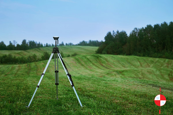
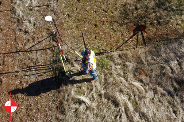
A topographic survey is a key tool for land development and construction that is used to establish elevations and relief. Topographical surveys offer a detailed, three-dimensional view of a property's natural and manmade features, marking the contours, elevations, and other features of the land. They provide property owners, developers, and other involved parties invaluable insights into the land’s unique characteristics. This type of land survey is most often utilized for site plans or new construction projects and typically includes things such as field measurement and preparation of a plat to establish land elevations. These surveys are usually conducted by residential or commercial property owners before making improvements to the property such as, but not limited to, additions, landscaping, or parking lots.
Topographical surveys serve as the foundational blueprint for architects, engineers, planners, and contractors. These surveys are critical for a variety of reasons. For starters, topographical surveys are essential for the design and planning process for any infrastructural project, such as buildings, roads, drainage systems, and more. A topographical survey can inform the design to ensure the natural landscape is integrated appropriately. Additionally, topographical surveys serve as an important guideline for environmental considerations by helping property owners and project managers assess the potential environmental impacts of their builds. With the help of a topographic survey, you can make the most sustainable, ecologically responsible decisions before it’s too late. Another very important role that topographic surveys play in any project is offering guidance for legal and regulatory compliance. Having an accurate topographic survey is essential for helping projects adhere to zoning laws, building codes, and other regulatory requirements. Topographic surveys are also critical tools for project rsk management. Understanding the details of the terrain helps identify potential issues, such as flood risks or land instability, mitigating future problems and expenses.
Whether you're in the metropolitan areas of Austin or Houston or are building in the natural landscapes that surround these major Texas cities, understanding the lay of the land is crucial for any project.
Having a reputable and dependable professional conduct your topographical survey is essential, because the complex process requires specialized skills, trade-specific tools, and in-depth knowledge. For Texas-based businesses, it is critical to hire a professional land survey firm that is familiar with the unique landscapes of Texas.
From Austin to Houston and throughout the cities’ surrounding areas, Waterloo Surveyors offers high-quality commercial and residential surveying services for all types of projects and situations. Regardless what your topographic survey needs may be, we are committed to streamlining the process and helping every step of the way.
With every topographic survey we perform, we aim to ensure a wealth of experience and a deep understanding of the geography, regulations, and unique challenges of the Austin and Houston areas of Texas. With access to advanced technology such as GPS, drones, and more, our professionals can capture highly accurate and detailed data, providing the most precise survey possible. Additionally, our team of Texas professionals conducts surveys swiftly and efficiently, minimizing delays in project timelines. By choosing Waterloo Surveyors for your project, you can have peace of mind knowing that your topographic survey is conducted by licensed professionals, helping avoid costly mistakes, building issues, and legal concerns down the line.
Waterloo Surveyors specializes in all types of surveys for residential and commercial clients alike, beyond topographical surveys, we also offer land survey services throughout Austin and Houston such as:
No matter your property size, our experienced boundary surveyors in Austin and Houston have proven to reliably and accurately establish or confirm lot boundaries.
Our team of professional boundary surveyors, located throughout Austin and Houston, specializes in ALTA/ACSM surveys, typically used for commercial property transfers or refinancing purposes. The precision and adherence to strict regulatory standards established by the American Land Title Association and American Congress on Surveying and Mapping that these surveys require means the job must be handled by the best of the best. With over a century of combined experience, our team has been trusted by countless clients for ALTA/ACSM surveys.
Platting prep services are a must for individuals or businesses engaged in land subdivision, reconfiguration, or consolidation, particularly for housing projects. Regardless of your specific needs, Waterloo's land surveyors in Austin and Houston are equipped to assist with all your plat preparation requirements.
Architects, developers, and builders utilize land and property surveys throughout every stage of the construction process. From retrofits to new construction, Waterloo Surveyors' teams in Austin and Houston are capable of delivering the full range of construction surveys needed by architects, designers, engineers, and construction teams.
The above services represent only a portion of the wide range of services provided by Waterloo Surveyors. For a complete overview of the comprehensive land and property survey types we offer, please click the links provided below.
● Boundary Surveys
● Title Surveys
● Elevation Certificates
● Topographic Surveys
● Construction Staking
● Form Surveys
● Site Plans
● Subdividing
● Plat Preparation
● Fence Line Staking
● Field Notes
● Easement Dedication
● Drone Mapping
Waterloo Surveyors - Austin and Houston Topographic Surveyors
Regardless if you are located in Austin or Houston, Waterloo Surveyors aims to be the trusted surveying partner you need. Our business is built on decades of service to the Texas community and our mission to provide Texas land and business owners the best possible land and property surveys remains unchanged today. We’ve upheld our dedication by delivering on-time, precise, and comprehensive surveys, ensuring accuracy and efficiency for our clients every time.
For more information, to make an inquiry about a specific project, or to receive a quote, reach out to us today. Waterloo Surveyors is here to meet your surveying needs with professionalism and unmatched expertise.